
Anacostia River Corridor
Restoration Plan
The Anacostia River Corridor Restoration Plan (ARCRP) was a three-year restoration planning project for the Anacostia River corridor within the District of Columbia. The plan identified and prioritized specific strategies for restoring fish and wildlife habitat, improving water quality, adapting to climate change, and increasing equitable public access to the river corridor.
The project included robust engagement efforts to foster strong community consensus around the plan for the Anacostia River’s future. The final report was released in November 2024.
Anacostia River Corridor Restoration Plan
Anacostia River Corridor Restoration Plan Appendices
Anacostia River Seawall Rapid Assessment:
To supplement the Corridor Plan, DOEE also conducted an assessment of the historic seawall that lines 17.2 miles of the mainstem of the Anacostia River in the District, as well as Kingman Lake, to better understand the seawall's structural, ecological, and historical integrity. This work resulted in two reports:
The Anacostia River Seawall Study
The Kingman Lake Seawall Study
These two reports were synthesized into an interactive GIS map to enable members of the public and policymakers to better understand the condition of the Anacostia River seawall and to guide historic preservation, ecological restoration, and climate resiliency planning decisions:
Anacostia River and Kingman Lake Seawall Study Discussion Pathway Tool (GIS Map)
See also: How to use the Seawall Discussion Pathway Tool
Project History
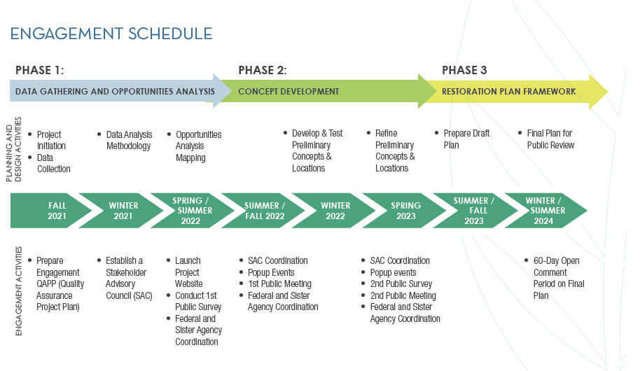
Our planning process involved three phases that were focused on meaningful engagement with residents and stakeholders at every level. Below is an overview of the project’s timeline that also includes archives resources related to public meetings and surveys.
-
This phase included the review and summary of existing plans and studies related to the Anacostia River and the project’s primary goals, including habitat restoration, resiliency enhancements, pollution reduction, and public access improvements. The planning team used this data to understand the current state and needs of the Anacostia River Corridor.
During this phase, the planning team engaged with the community through surveys and community conversations at local events and a public meeting where community members shared their input on important issues and concerns and a project vision and goals.
Public Meeting Materials:
Phase 1 DC ARCRP Community Meeting, September 22, 2022: Participant Comment Summary
-
During this phase, the planning team used the data compiled from the first phase of the project to select potential restoration and public access concepts that addressed the needs of the river corridor identified by the data and input provided by stakeholders and the community.
The planning team shared these concepts and potential locations where they could be incorporated. Stakeholders then provided feedback to refine an approach toward a final restoration master plan framework.
Public Meeting Materials:
Phase 2 DC ARCRP Community Meeting, June 8, 2023: Presentation Deck
-
The planning team prepared a document that provided final restoration recommendations as well as an implementation plan and suggestions for future studies to support these efforts. The master plan draft is now being presented to the public to continue transparency and engagement with the public.
-
The leading charge of Stakeholder Advisory Council (SAC) members was to help advise DOEE on conducting outreach and engagement for this project. The Committee was intentionally and mindfully designed to include a diverse representation of District community members and leaders.
Resources:
-
DOEE and it’s team of consultants conducted two public surveys to gather feedback on proposed strategies for the future of the Anacostia River. In total, 849 participants provided over 12,600 responses and comments and invaluable insights which helped shape the final corridor restoration plan.
2022 Anacostia River Corridor Public Survey
Click here to read the 2022 Survey Report
2023 Anacostia River Corridor Public Survey
-
Public meetings were held during each phase of the project to provide opportunities for residents, local leaders, business owners, and other stakeholder an opportunity to receive updates about the project and provide input.
Anacostia River Corridor Restoration Plan Community Meetings
Phase 1 DC ARCRP Community Meeting, September 22, 2022: Participant Comment Summary
Phase 2 DC ARCRP Community Meeting, June 8, 2023: Presentation Deck
-
Please contact the Offie of District Waterways Management at odwm@dc.gov if you have any questions or to share your comments about this project.